
Geophysics
The airborne magnetic data generated by the Mexican Geological Survey, provides information that can be used, together with the geological and geochemical maps, in mining exploration, radioactive minerals detection, cavities location to prevent geological risks, contouring the rock basement, assessment of aquifers, intrusive rocks delineation, and detect hidden subsurface mineralized bodies.
The 24 enthusiastic and compromised professionals working in the field and in the office to carry out the survey and the further digital process and data interpretation, are organized in two specific task groups: airborne geophysics, and ground geophysics, both teams distinguished by their experience, results and high quality management of the software and equipment, a key to gain plentiful prestige of companies, agencies and national and foreign government institutions.
Infrastructure
- 24 geophysicists and specialized technicians.
- 1 turbo-charged Islander aircraft. 1 Piper Navajo Panther each equipped with cesium vapor magnetometers.
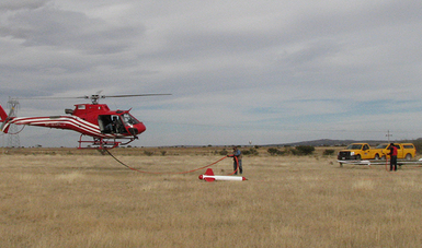
- 2 Eurocopter helicopters B-2 and B-3 with magnetometer and gamma-ray spectrometer with 256 channels.
- In June 2011, a miultispectral chamera (hiperspectral), and an aerial electromegnetic equipment.
- For ground surveys, equipment of Induced Polarization, electromagnetics, gravimeters, magnetometers, gamma ray spectrometers, one seismometer and one borehole recorder.
- 21 desktop and laptop computers.
- 1 ink injection plotter.
Products
The magnetic cartography products are widely variable. The maps can be issued with contours and colored-outpointed intervals; gray colored relief, or combined with the digital elevation model. Can be purchased in paper or in digital format, and also can be consulted –some of them freely– in the SGM web page. The main scales are 1:250,000 and 1:50,000. The state maps are issued in 1:250,000, 1:500,000, 1:750,000 and 1:1’000,000 scales. The Mexican Republic Magnetic Map is available in 1:3’000,000 and 1:4’000,000 scales.
- Total magnetic field (TMI).
- Total magnetic field reduced to the magnetic pole (RTP).
- First vertical derivative (1VD) of the TMI.
- Digital elevation model (DEM) with a magnetometric layer.
- Digital files by flight lines in any specific area. Grids at 1:50,000 or 1:250,000 scale maps.
- Report and guide text of the magnetic maps, 1:250,000 scale.
Professional experience
In geophysics, the Mexican Geological Survey is a leader with up to 50 years of experience along which has performed the next works:
- Aeromagnetic coverage of the Mexican territory.
- Since 2005 were implemented the helicopter high resolution surveys, a combination of magnetic and radiometric techniques.
- Ground geophysics in mining exploration, uranium and coal deposits, geological risks (urban, mainly), location of underground aquifers, water salinity, archeology.
North America Magnetic Map project:
A unique and transcendental experience was the assemblage of the North America Magnetic Map, published in agreement with the United States and Canada geological surveys. This ambitious project of exemplar collaboration was the result of the combined efforts of those three countries to bring together and homologate the airborne magnetic files issued by each one.
This modern digital database of the North American magnetic anomaly is a powerful tool to analyze the geological processes, the structural setting and the regional tectonic evolution, as well as a strong support for the continent and the ocean resources exploration. The magnetic map of North America provides a continental scale vision of the magnetic lineaments that locally could not be appraised.
The data processing details and the compilation are described in the brochure accompanying the map.
Application examples of the magnetic map of North America:
Organization
The airborne geophysics technical team produces information at a high rate, so to December, 2009, an Accumulative advance of the 2’025,000 line km of regional magnetometry were archieved. The systematic flights are settled in N-S lines separated 1,000 m, at an altitude of 300 meters over the terrain surface. The high resolution coverage is done with a helicopter over lines spaced 250 m, and at an altitude of 120 meters over the terrain surface. They include the spectrometric gamma-ray record.
The ground geophysics division operates with magnetometer, gravimeter, induced polarization and resistivity; seismograph and electromagnetic equipments, and borehole logging. The provided information applies and support geological mapping, mineral deposits exploration, geo-hydrological and geo-technical surveying interpretation, and environmental assessments, so ground geophysics can be used as a tool that permit more accurate decisions in the underground searching.
It is important to remark that the Geophysical team of the SGM definitively supports the geology and mineral resources, hydrogeology and risk studies areas, as well as the requirements of private companies; the federal, state and local municipality governments, and also work together with search institutions concerned with the earth crust resources, or to prevent geological risks.
Geophysical activities are certified under the ISO 9000-2008 standard to guarantee excellence in the quality management of the processes and services. On the other hand, the personnel are permanently updated in software and research techniques in order to improve and meet the client’s requirements.
For further information, please contact
Ing. Javier Lara Sánchez
Gerente de Geofísica
Tel.: 01(771) 711-36-96 ext. 1291
javierlara@sgm.gob.mx
Ing. Antonio Cano Martín
Subgerente de Geofísica Terrestre
Tel 01(771) 7113696 ext. 1294
antoniocano@sgm.gob.mx
Ing. David Berrocal Huerta
Subgerente de Geofísica Aérea
Tel 01(771) 7113696 ext. 1256
davidberrocal@sgm.gob.mx
 Geophysics
- Autor:
- Servicio Geológico Mexicano
- Fecha de publicación:
- 26 de septiembre de 2017
La legalidad, veracidad y la calidad de la información es estricta responsabilidad de la dependencia, entidad o empresa productiva del Estado que la proporcionó en virtud de sus atribuciones y/o facultades normativas.